Agri-Modelling
 |
 |
|
|
|
The North Wyke Farm Platform provides a response to the needs of modellers who have long required more agri-environmental data for simulations regarding sustainable agriculture, providing data for agri-model input and calibration data to compare with simulated output. This website provides a guide to using the Farm Platform Data Portal for data, splitting it into input data and calibration data. We provide some examples of results produced using the models we have used. Please let us know if you have used the Farm Platform data for your modelling, we would appreciate your feedback on how easy or difficult you found the Data Portal. The aim is that the Data Portal supplies data on temperate high rainfall grassland livestock systems internationally for models to use the Farm Platform in their simulations. |
Rothamsted North Wyke has a long history of modelling experimental data, for example the SIMSDairy model. Models currently being used with data from the farm platform include:
|
||
 |
How to use the Data Portal and Guides for modelling |
|
When using the Farm Platform Data Portal for the first time, a good familiarisation to the North Wyke Farm Platform and the data is to:
- User Guide to the 15 Minute Hydrology and Water Quality Data - User Guide to the 15 Minute Soil Moisture Station Data - User Guide to the 15 Minute Meteorological Data
Reading the explanatory guides are a very important step, and not to be bypassed but the explanatory information may be absorbed and understood better when you have familiarised yourself with the datasets available. |
|
 |
Datasets suitable for process model input |
|
Soils information can be gained from:
Weather data can be obtained from:
Field management data including fertilizer applications and silage cutting operations can be gained from:
Stock numbers per field can be gained from:
*The field events files are described in farming operations terms, hence the Defra RB209 Fertilizer Manual is useful for conversion. Ready- converted fertilizer to elemental amounts are included here for the fertilizer types used on the Farm Platform. |
|
 |
Datasets suitable for process model calibration and validation |
Crop Production
Soil moisture sensor
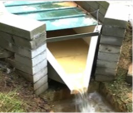
Flume runoff flow & nutrients in runoff water
Above-ground herbage nitrogen & carbon
|
|
 |
 |
Extra data which may be useful in modelling is to be found on the 'User Guides, Information, Data Portal Updates and External Links' webpage in the 'Supplementary Data, Information and File Downloads' section. This supplementary file store is very useful for models using a daily time-step since it contains statistical summaries of the 15-minute datasets, including daily weather data, flume measurements and soil moisture, temperature and field precipitation. The file store also contains GIS shape files for the farm platform fields. Links to further sources of data, including datasets from the same North Wyke site as well as other sites, are given on the webpage in the 'Useful Links to External Data Repositories and Associated Organisations' section. |
 |
Process modelling has been carried out using the data of the Farm Platform, here are some results which could be used in comparison to your modelled output: |
 |
The SPACSYS model (Wu et al., 2007) is a field scale, weather-driven and daily-time-step dynamic simulation model. The current version includes a plant growth and development component, a nitrogen cycling component, a carbon cycling component, a phosphorus cycling component, plus a soil water component that includes representation of water flow to field drains as well as downwards through the soil layers, together with a heat transfer component. The model has a capability to simulate the interaction of C, N, P, soil water and temperature in the soil-plant-atmosphere continuum system. The main processes concerning plant growth in the model are plant development, assimilation, respiration, and partition of photosynthate and nitrogen from uptake estimated with various mechanisms implemented in the model, plus N fixation for legume plants, and root growth and development that is described in 3D root system by the following processes: branching, extension, architecture, mortality, water uptake and nutrient uptake. An alternative 1D root system is implemented to simplify processes involved in root growth and development. The functionality on water and nitrogen uptake by roots is also quantified. The model has been used to investigate a number of issues including nitrate leaching, resource use efficiency by crops, root systems, GHG emissions and and the responses of cropping/grassland systems on environmental changes. The model can address the questions, such as, how to increase N and water use efficiency through manipulating genetic traits of plant root architecture; what field managements to mitigate GHG emissions and diffuse pollution; how response of plants/cropping systems to climate change and carbon sequestered into soils with land use change. Wu, L., McGechan, M. B., McRoberts, N., Baddeley, J. A., Watson, C. A., 2007. SPACSYS: integration of a 3D root architecture component to carbon, nitrogen and water cycling - model description. Ecol. Model. 200, 343-359. (doi:10.1016/j.ecolmodel.2006.08.010) |
 |
DAYCENT is the daily time-step version of the CENTURY biogeochemical model (Parton et al., 1994). DAYCENT simulates fluxes of C and N among the atmosphere, vegetation, and soil (Parton et al., 1998). Submodels include soil water content and temperature by layer, plant production and allocation of net primary production (NPP), decomposition of litter and soil organic matter, mineralization of nutrients, N gas emissions from nitrification and denitrification, and CH4 oxidation in non-saturated soils. Operators create a schedule file which calls in modules for field management and makes it possible to manage operations on a daily basis. Model outputs include: daily N-gas flux (N2O, NOx, N2), CO2 flux from heterotrophic soil respiration, soil organic C and N, NPP, H2O and NO3 leaching, and other ecosystem parameters. Parton, W.J. and Rasmussen, P.E. 1994. Long term effects of crop management in wheat/fallow: II. CENTURY model simulations. Soil Science Society of America Journal 58: 530-536. Parton, W.J., Hartman, M., Ojima, D., Schimel, D. 1998. DAYCENT and its land surface submodel: description and testing. Global Planetary Change, 19, 35-48. |
 |
SH2O-NW is a simple but effective soil water model to predict the soil moisture stored in the root zone and determine field runoff from soil (Shepherd et al., 2002). The model has been validated for the North Wyke Farm Platform (Shepherd et al., 2016), and is parsimonious requiring available water capacity and soil runoff curve number plus meteorological data. Water availability in the root zone involves a water balance in which effective rainfall, runoff and evapo-transpiration are the main factors. The model assumes that in the absence of a water table, effective rainfall is the only source of water. The effective rainfall is calculated from rainfall minus surface runoff. If the available water is below a critical threshold, the crop demand cannot be met. The relative reduction in water use is related to the ratio of the available water and the water holding capacity. A. Shepherd, S.M. McGinn, G.C.L. Wyseure. 2002. Simulation of the effect of water shortage on the yields of winter wheat in North-East England. Ecological Modelling, 147(1), 41-52. A. Shepherd, W. Atuhaire, L. Wu, D. Hogan, R. Dunn and L. Cardenas (2016). Historic record of pasture soil water and the influence of the North Atlantic Oscillation in south-west England. Hydrology Research. (doi:10.2166/nh.2016.195) |